


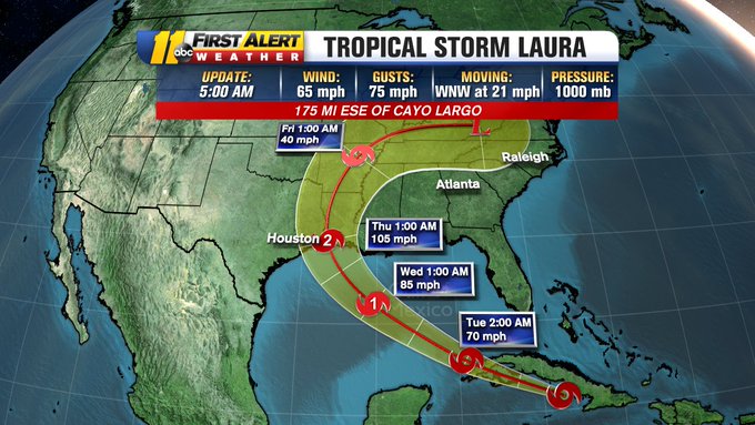
RALEIGH, N.C. (WTVD) — Hurricane Laura is nearing Category 5 status Wednesday as it continues to creep closer toward the Texas-Louisiana border. The National Hurricane Center called the hurricane “extremely dangerous.”
As of 10 p.m. EST, the National Hurricane Center says Laura has maximum sustained winds of 150 mph with higher gusts. That’s 7 mph shy of becoming a Category 5 hurricane.
The eye remains about 45 miles off the Louisiana coast and is expected to make landfall around 1 a.m EST on Thursday.
However, the extremely strong wind may not be the most pressing issue for people caught in the storm’s path. The National Hurricane Center said Laura will bring “unsurvivable storm surge with large and destructive waves” to areas near the Texas-Louisiana border and as far as 40 miles inland. The NHC predicts flood waters will not fully recede until several days after the storm.

Galveston, Texas has already issued a mandatory evacuation, instructing all residents to leave the island Tuesday.
Recent forecasts show Laura making landfall somewhere between central Louisiana and Houston. This will be the first Category 4 hurricane to make landfall on this part of the Gulf Coast.
Forecasters warn that seawater higher than a basketball hoop could swamp entire communities.
Towns near the Louisiana-Texas state line are bracing for the worst. Laura already killed at least 11 people in the Dominican Republic and Haiti, where it knocked out power and caused flooding in the two nations that share the island of Hispaniola.
Laura would transition to a post-tropical depression and work its way through the Ohio River Valley and could race east to bring North Carolina some rain Friday night into Saturday. Laura could carry tropical-storm-force winds into Arkansas
Fujiwhara effect: Can 2 hurricanes merge into a megastorm?
??? ???????????@BigweatherABC11

Marco brought heavy rain, gusty winds and significant storm surge to parts of the gulf coast Monday night into Tuesday morning. Marco made landfall near the mouth of the Mississippi River, close to New Orleans around 6 p.m. Monday night but the ragged storm continued to weaken.
Source: https://abc11.com/hurricane-laura-path-national-center-update/6389346/
[Disclaimer]